Welcome to the blog of the sailing yacht Sea Bunny.

Monday, April 11, 2016

Cape Town - Robben Island

When in Cape Town it is almost mandatory to take the ferry over to the former prison island of Robben Island. We went on a Saturday which meant that there were vast crowds and it was impossible to view the information boards while waiting in the queue for the ferry, which passed through strict airport-style security checks.

Mandela's cell
Large numbers of political prisoners, almost all black or coloured, were imprisoned here during the apartheid years including, of course, for 16 years, Nelson Mandela.
Cells were Spartan with just a sleeping mat and pot.
Exercise yard
Our guide around the prison block had himself been a prisoner here for around 11 years. His crimes – sabotage, belonging to a banned organization and attempting to leave the country. Being pedantic one could consider that sabotage would be a criminal, rather than a political act. He did briefly describe the types of torture.

The quarry
Life was harsh – one hour in the exercise yard, hard labour in the quarry
All in all, perhaps not as horrific as the Cellular Jail in Port Blair, Andamans, built by the British to house Indian political prisoners.

Photo stop
The bus trip round the island only had one stop - queue up to take a "selfie".

Saturday, April 9, 2016

Cape Town - Signal Hill

The smoke shows the firing point
We went up Signal Hill believing that the noonday gun was fired from the top, only to discover that it is in fact fired from lower down the hill. We could see the puff of smoke.
Table Mountain from Signal Hill
There is a good view of Table Mountain from here.

Also another form of quick way down.

Friday, April 8, 2016

Cape Town - Table Mountain

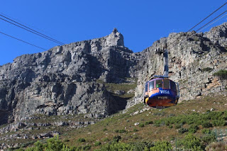
The easy way up and down
4 March dawned with light winds and clear skies. Just the day to go up Table Mountain.
There are two ways up and three down. We took the easy way both up and down. The path is, apparently, challenging on the way up and very challenging on the knees on the way down.
The quick way down
The quickest way down appears to be abseiling.

Cape Town and Table Bay
The views over Cape Town and across to Robben Island are spectacular.
Signal Hill and Robben Island

Marked trails around the top of the mountain keep you away from the edge and lead to the viewpoints and rocks for a rest.

Namibia - Bagatelle Game Farm

Desert view
On our last night before the 4WD camper was returned, we opted for the Bagaelle Game Farm on the edge of the red Kalahari Desert.

African wild cat
We arrived just in time to go on the organised game drive/cheetah feeding/sundowner combination. Most of the game drive was spent trying to locate giraffes by their droppings. You'd think that, with their long necks they'd be easy to find, but not so. We did see some wildlife we'd not seen in the wild before – a wild cat and a pied hornbill.
Pied hornbill


Cheetah waiting for his dinner
The cheetahs are rescued ones and in a compound but still have to be treated with caution.

1
At the sundowner gathering one of the staff (possibly the owners' son) demonstrated trust between him and his horse by getting the horse to lie down with him on top and then getting to its feet with rider in the saddle
2

3

4

5

6

Susan at sunset
The sunset was quite impressive.

Namibia - Fish River Lodge

Ever since we first planned to take Sea Bunny to southern Africa, Susan had wished to see Fish River Canyon and stay in the only accommodation that is actually on the rim of the canyon – Fish River Lodge. Although only some 11 km from the viewpoints on the eastern side of the canyon, it is a 250 km drive!
View from our verandah
The Lodge comprises 20 individual chalets perched some 5 metres from the cliff edge, from where it is around 350 m vertical to the upper canyon floor. You have to remember to turn right onto the verandah when returning to the chalet.
Quiver trees
There are self-guided trails along the canyon rim on both sides of the lodge. We took a walk along the one to the south.
On the edge

View back to the lodge - our chalet is 1st to the left of the main building

The canyon at sunset
A sunset drive and sundowners at a viewpoint revealed some animal life and more spectacular scenery.
Rock dassie 
The highlight was the drive down to the river. This involves a 3 hour descent by 4WD along some fairly challenging tracks – we were glad not to be driving.
on the way down
The first stage was to the upper canyon – 350 m vertical...
View down to the canyon bottom

Not for the faint hearted
...and the second 200 m vertical to the river.
The river at last

The Lodge can organise camping here

or swimming

Namibia - Fish River Canyon east

View from the Main Viewpoint
Fish River Canyon is, by many measures, the second largest in the world after the US's Grand Canyon. However there is little serious commercialisation of this. On the eastern side of the canyon there is a campsite, within the National Park, a few lodges some km outside the park, a main viewing area and a few viewpoints.

Hikers' Viewpoint
Descending into the bottom of the canyon from here, at Hikers' viewpoint  is prohibited except as part of an organised hike – taking 5 days. There is apparently only one "emergency exit" so hikers have to be well prepared, fit and self sufficient.,

View across to Fish River Lodge
From Hikers'Viewpoint we could see our next accommodation, Fish River Lodge, on the western rim of the canyon – 11 km away
Main Viewpoint from Hiker's Viewpoint

Further down
Each viewpoint gives a slightly different perspective.

and further
 The road to one of the viewpoints has a sign "4WD ?".While we reckon it could have been reached in a 2WD vehicle, we were glad we had a 4WD!


Ai Ais
By contrast, the end of the canyon at Ai Ais, where there is a large resort and campsite, is somewhat disappointing

Namibia - Sossusvlei and the dunes

At viewpoint beside the road
The road south passed through some more spectacular scenery before leaving the hills and entering the flatter, sandier part of the desert.

Lots of sand...
The Namib Nauklauf desert has some of the largest sand dunes in the world. The gate into the National Park is at the settlement of Sesreim, consisting of the NP facilities, including a campsite, an upmarket lodge and a campsite/petrol station/convenience store complex. We stayed at this campsite which provided individual shower, toilet facilities and braai facilities for each for each pitch.

...and more sand

Dune 45
The dunes are numbered by their distance from the national park entrance. Dune 45, about 47 km from the entrance has a parking site and is the one that is most climbed. Presumably by providing the parking the park authorities seek to limit the environmental impact of uncontrolled climbing of many dunes.

The path up Dune 45
Climbing a large sand dune is not easy. The last time we did it was in the Sahara in the late 70s when the attraction for our children was to slide down. Going up the sand ridge involves taking a stride up and losing half or more of the height gained as the sand on which you have planted your foot slides back. Walking in someone else's footprints helps as the sand is more compacted ("Mark my footsteps good…").

A bit further to go
We decided that the view from halfway up was good enough.

Lizard - look carefully!
Apart from the tourists the environment seems to support small lizards. When they stop running they lift their tails and stand on their front legs - presumably to minimise contact with the hot sand.

Going down is easier
On the descent we saw that someone had decided to take the short way down rather than follow the path on the ridge – he got seriously bogged down in very fine. loose sand.


The windward side is reasonably firm - the other side is very soft


Dead Vlei
The paved road through the dune area leads to a dry pan – Sossusvlei, but there is a parking area some distance before reading it where commercial tours are supposed to park their vehicles before visitors gat a shuttle vehicle to the pan. The guide book says that many visitors walk the last part and take the shuttle back, so that is what we decided to do. After a couple of hundred metres, just as we were considering whether this was a good idea, one of the shuttle vehicles stopped and we got on.
The shuttle dropped us at the side of the road and pointed out the path to Dead Vlei – as its name suggest this is a very dry pan where most of the vegetation has died. The driver arranged to pick us up in an hour and a quarter. Having got to the Vlei, we were back in 45 minutes and had to prove to the driver, by a photo, that we'd actually seen it!

Sossusvlei
Sossusvlei itself, although also dry, had more vegetation and wildlife.